
Market Trends
Farrukhnagar Future Development Plan: What's on Record in 2026
We hold no development plan map for Farrukhnagar, so we can't show its future zones or roads. What our records do show is a town with its own Sectors 1 and 3, ten HRERA registrations since 2021, and the Dwarka Expressway crossing the Farukhnagar road (SH-15A) near Basai.
 By Prerna Sharma · Edited by
Rakesh Mahajan · · 10 min read
What is the future development plan for Farrukhnagar?
We don't hold Farrukhnagar's development plan, so we can't show its future zones, sectors or roads. What our records do show is a town with its own Sectors 1 and 3 and ten HRERA registrations since 2021. They also show the Dwarka Expressway crossing the Farukhnagar road (SH-15A) near Basai. For the plan itself, check the Town and Country Planning Department's development plan for Farrukhnagar.
This post sets out what's on record, what isn't, and how to check a piece of land against the plan before you buy. It doesn't guess at what the plan contains.
What is a development plan, and how do you read one?
A development plan is the Town and Country Planning Department's map of how a town is meant to grow. It splits the area into zones, such as residential, commercial, industrial, public use and agricultural. It also marks sector boundaries and the main sector roads.
A zone on the plan isn't permission to build. A colony in a residential zone still needs a DTCP licence, the department's licence to develop a colony on named land. A single site needs a CLU, or change of land use, before it's used for anything but farming. Land the plan keeps in its agricultural zone stays farmland, recorded for farming rather than housing.
When you read a plan, find the land's sector or field numbers first, then its zone, then the nearest planned road and its width. Ask for the latest version, since plans get revised. A draft revision is normally published for public objections before it becomes final, so a draft map isn't the last word. Our planned guide to the Haryana development plan and future residential sectors explains the zones in more detail.
What do HRERA registrations show about Farrukhnagar's growth?
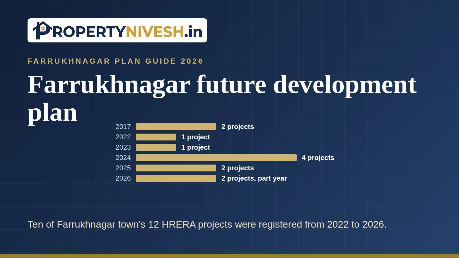
They show a town that started filling up from 2022. HRERA, the Haryana Real Estate Regulatory Authority where projects register before they sell, lists 12 projects in Farrukhnagar town. After two records in 2017, nothing was filed until 2022.
| Year | Projects | Plotted colonies | Plots | Units | Land (acres) |
|---|---|---|---|---|---|
| 2017 | 2 | 0 | Not filed | Not filed | Not filed |
| 2018 to 2021 | 0 | 0 | 0 | 0 | 0 |
| 2022 | 1 | 1 | 129 | 129 | 7.02 |
| 2023 | 1 | 1 | 253 | 253 | 12.29 |
| 2024 | 4 | 2 | 453 | 1,589 | 33.19 |
| 2025 | 2 | 1 | 107 | 1,492 | 14.56 |
| 2026 (to 14 September) | 2 | 2 | 215 | 215 | 13.4 |
The chart shows HRERA registrations by year in Pataudi town, Farrukhnagar town and Sohna, so you can see Farrukhnagar's pace against the other two.
2024 was the busiest year, with four projects, including Diplomats Green Vista's 1,124 affordable group housing units. 2025 brought Nakshatra by Nowara's 1,385 units. Those two projects are why the unit count jumps in those years while plot counts stay modest. None of the 12 records has lapsed or been cancelled.
Which Farrukhnagar sectors are filling up?
Sector 3 holds almost everything. Ten of the 12 records give a Sector 3 address, from Amaya Greens in 2017 to Keshav Kunj 2 in February 2026. Sector 1 has a single record in our data, Hemis One, registered in March 2026 with 85 plots and an address in Sultanpur.
These are the town's own sector numbers, separate from Gurugram's. Our records name only Sectors 1 and 3, and they don't say how many sectors the town's plan has or where each one lies.
That's a gap only the plan can fill. If you're shown land "in a new sector", check the sector number against the development plan, then look for a DTCP licence on that land. For how new sectors come about across the district, see new sectors planned around Gurgaon.
Which roads are on record near Farrukhnagar?
One road record ties in directly. A Press Information Bureau release of 18 May 2023 says the Dwarka Expressway crosses the Farukhnagar road, SH-15A, near Basai. The same release says it crosses Pataudi Road (SH-26) near Harsaru.
The expressway's Haryana section is operational. The package from the Basai ROB (road over bridge) to Kherki Daula was awarded on 1 March 2018. Work on the stretch from the Delhi border to the Basai ROB started on 29 November 2018. The Prime Minister inaugurated the 19 km Haryana section on 11 March 2024.
Basai sits in the Kadipur tehsil's collector list, and its residential plot line rose 15% in 2026-27. We hold no distance or travel time from the crossing to Farrukhnagar town. Our Dwarka Expressway investment guide covers the corridor itself.
You may also hear the KMP Expressway in a sales pitch. We hold no route record for it, and no line in Farrukhnagar's 2026-27 collector list names it, so we can't say which villages it touches. Check its alignment on the development plan, and see our post on land near the KMP Expressway for the little we do hold.
What does the 2026-27 collector list hint at?
It shows where the state revised its official values, which isn't the same as a plan. A collector rate is the minimum value for registering a deal, set by the Deputy Commissioner Gurugram's office. In Farrukhnagar tehsil, the revenue area around the town, farmland lines rose by a median 30% across 99 lines. Residential lines held at 0% across 48.
The list's own rules echo planning terms. Land in the "Farrukhnagar R-Zone" is valued at two times the agriculture rate. Land with a change of land use is valued at multiples of it. That's three times for a residential plotted colony and two times for industrial or warehouse use.
Roads already carry weight in the list. All 40 village groups have a separate "2 Acre From Road" line for farmland along a road, and its lines rose by a median 30% across 64 lines. Land on a National Highway or NPR is assessed 20% above the normal value up to two acres deep. Whether land beside a future road would get a frontage line is for a later list to show, so ask the tehsil office.
The list doesn't define the R-Zone's edges, so check them on the plan. Village by village changes are in our Farrukhnagar property rates post.
What would show Farrukhnagar's plan is moving forward?
Watch for things you can see on paper and on the ground, not promises. A plan only turns into a town when licences, roads and services follow it.
- New sector numbers in HRERA addresses. So far our records name only Sectors 1 and 3. A filing that gives a new Farrukhnagar sector number would show the plan opening up further.
- More licences in Sector 1. Hemis One is the only Sector 1 record we hold. More colonies there would show the second sector filling in.
- Sector roads being built. A road drawn on the plan helps little until it's laid. Check whether the road next to a plot exists, not just whether it's planned.
- Services in place. Water, sewer and power lines inside a licensed colony tell you more about readiness than a brochure does.
- Plan revisions. Look out for any draft or final revision of the Farrukhnagar plan from the Town and Country Planning Department.
None of these is a price signal on its own. Together they show whether the town is growing along the lines the plan sets out. If you're also weighing warehousing land in the tehsil, see Farrukhnagar warehouse land investment.
What don't we know about Farrukhnagar's future?
Quite a lot, and it's better to say so than to fill the gaps with guesses. Here's each gap and where to check it.
- Zones and sector boundaries. We hold no plan map. Check the Town and Country Planning Department's development plan for Farrukhnagar.
- Licences. We don't hold DTCP licence records for the town's colonies. Ask the developer for the licence number and verify it with the department.
- New projects. Our HRERA data runs to 14 September 2026. Check HRERA Gurugram's register for anything newer.
- Roads. We hold no alignments, widths or dates for new roads around the town, and no KMP route. Check the plan's road network.
- Distances and prices. We hold none for Farrukhnagar. Don't rely on a brochure's travel times without driving the route yourself.
- Land titles. Check the jamabandi, the village land record of owners and shares, at the tehsil office.
For the projects we do track across the district, see our Gurgaon infrastructure impact report.
How can you check a plot against the Farrukhnagar development plan?
Use five steps, in this order, before you pay anything.
- Get the field (khasra) numbers from the jamabandi for farmland, or the sector and plot number for a colony plot.
- Find that land on the latest development plan for Farrukhnagar, and note its zone and the nearest planned road.
- For a colony, match the DTCP licence area to the plot, and the HRERA registration to the project.
- Find the land's line in the 2026-27 collector list for Farrukhnagar tehsil from the Deputy Commissioner Gurugram's office.
- Work out stamp duty, which in Haryana is 7% for men and 5% for women, on the price or the collector value, whichever is higher. Rates can differ for land outside municipal limits, so confirm the rate for your deed with the sub-registrar.
Our stamp duty calculator handles the last step. For the full Farrukhnagar series, start with our Farrukhnagar land investment guide, and for registered colonies see residential plots near Farrukhnagar.
Questions
Frequently Asked Questions
Is there a development plan for Farrukhnagar? +
Farrukhnagar town has its own sector plan, and HRERA records name its Sectors 1 and 3. We don't hold the plan map, so we can't show its zones or roads. Check the Town and Country Planning Department's development plan for Farrukhnagar, and ask for the latest version, since plans can be revised.
Which sectors are there in Farrukhnagar? +
Our HRERA records name two: Sector 3, with ten of the town's 12 projects, and Sector 1, with one plotted colony registered in March 2026. These are Farrukhnagar's own sector numbers, separate from Gurugram's. We don't know how many sectors the plan has, so check the development plan before trusting a sector number.
Does the Dwarka Expressway pass through Farrukhnagar? +
Our records don't say so. A Press Information Bureau release of 18 May 2023 says the Dwarka Expressway crosses the Farukhnagar road, SH-15A, near Basai, and Basai falls in the Kadipur tehsil's collector list. We hold no distance or travel time from that crossing to Farrukhnagar town.
Will the KMP Expressway raise land prices in Farrukhnagar? +
We can't say. We hold no route record for the KMP Expressway, no line in Farrukhnagar's 2026-27 collector list names it, and we hold no Farrukhnagar price series. Check the road's alignment on the development plan, and treat any price promise linked to it with care until you've verified the route.
How many new projects are registered in Farrukhnagar? +
HRERA Gurugram lists 12 projects in Farrukhnagar town in records up to 14 September 2026. Ten were registered from 2021 onward, including two in 2026 so far, Keshav Kunj 2 and Hemis One. Seven of the 12 are plotted colonies, and none has lapsed or been cancelled. Check the register for newer filings.
Sources
- HRERA Gurugram registered projects, records 14 June 2017 to 14 September 2026, via Property Nivesh research store, October 2026
- Press Information Bureau, Dwarka Expressway release, 18 May 2023, via Property Nivesh infrastructure records
- Dwarka Expressway (NH-248BB) Haryana section milestones, NHAI and PIB releases, Property Nivesh infrastructure records, status as of 9 October 2026
- Farrukhnagar tehsil collector rate list 2026-27 (Deputy Commissioner Gurugram), official percentage changes and valuation rules extracted by Property Nivesh research store, October 2026
- Kadipur sub-tehsil collector rate lists 2025-26 and 2026-27, Property Nivesh research store, October 2026
- IANS via NewKerala, Haryana stamp duty rates, 28 July 2026