
Investment Guides
Best Areas to Buy Land Near KMP Expressway: What Our Data Shows
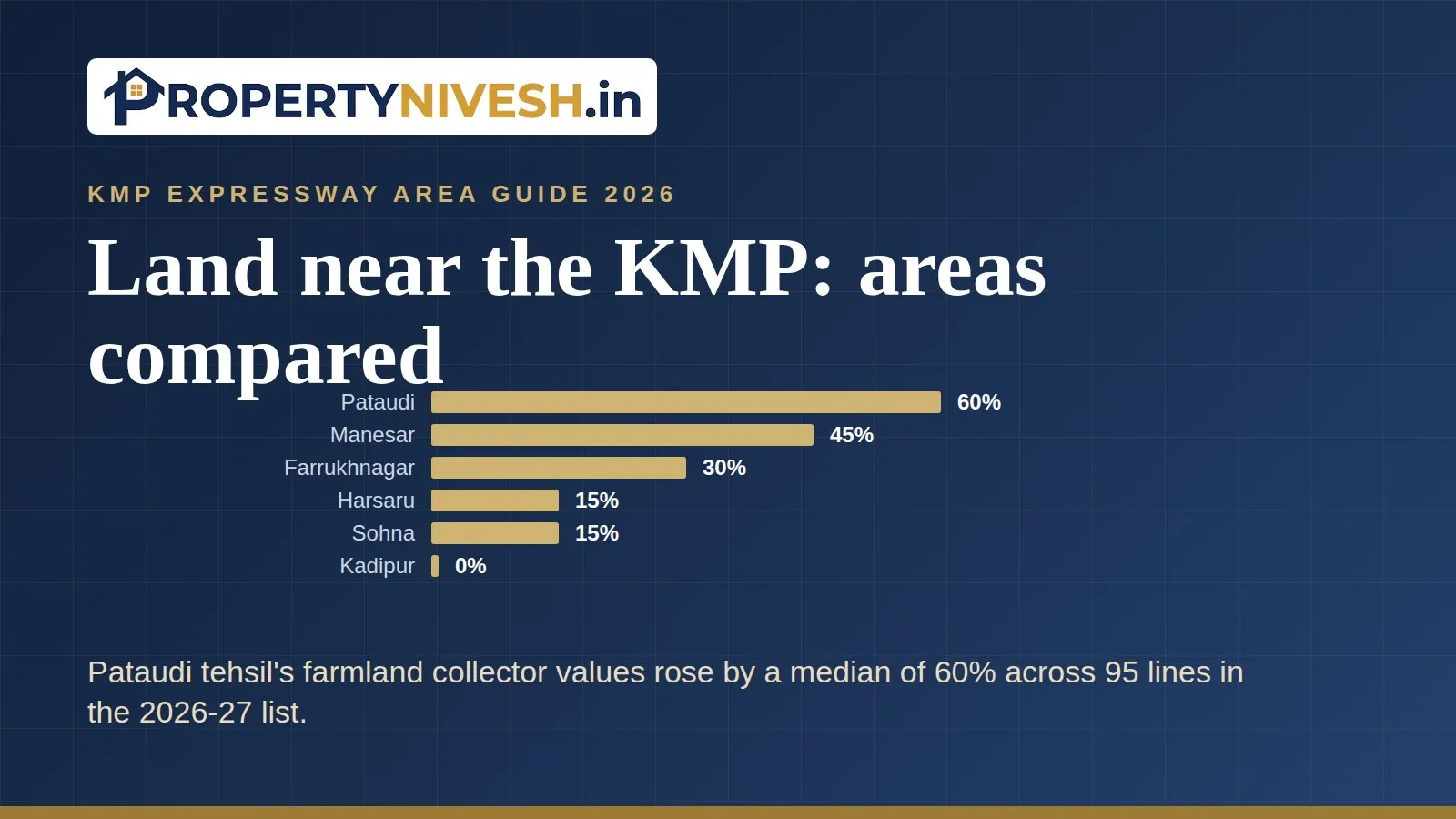
Our records can't place any village, sector or town on the KMP Expressway, so no area can be ranked by how close it is. By the measures we do hold, Pataudi tehsil's farmland collector values rose most in the latest lists (median 60% across 95 lines), ahead of Manesar (45%) and Farrukhnagar (30%).
 By Prerna Sharma · Edited by
Rakesh Mahajan · · 9 min read
Which areas near the KMP Expressway can our data compare?
None by how close they are to the road, because our records don't place any village, sector or town on the KMP Expressway. What we can compare is how official land values moved in the tehsils around Gurugram, and how the road-frontage belts in the Farrukhnagar and Pataudi lists moved.
So "best" in this guide means one thing: the largest official increases and the most registered activity in our data. It isn't a pick of any village or project. A collector rate is the minimum value Haryana sets for registering a property deed. It isn't a market price, and we publish only its percentage changes.
A tehsil is a revenue sub-division of the district, with its own registry office. If you want the buying checklist rather than the comparison, read our guide to land near the KMP Expressway for investment.
Which tehsils saw the biggest farmland collector changes?
Pataudi led, Manesar came second and Farrukhnagar third. Four of the nine tehsils in our data showed no median change in farmland at all in the latest list.
| Tehsil | Lists compared | Farmland lines | Median change |
|---|---|---|---|
| Pataudi | 2026-27 list (old 2025 to final 2026 rate) | 95 | 60% |
| Manesar | 2025-26 to 2026-27 | 84 | 45% |
| Farrukhnagar | 2026-27 list (old 2025 to final 2026 rate) | 99 | 30% |
| Harsaru | 2025-26 to 2026-27 | 46 | 15% |
| Sohna | 2025-26 to 2026-27 | 118 | 15% |
| Badshahpur | 2025-26 to 2026-27 | 40 | 0% |
| Gurugram | 2025-26 to 2026-27 | 24 | 0% |
| Kadipur | 2025-26 to 2026-27 | 41 | 0% |
| Wazirabad | 2025-26 to 2026-27 | 57 | 0% |
Read the line counts as well as the medians. Farrukhnagar's list is hard to read, and 99 of its 115 farmland lines passed our validation check. Its 2025-26 list is an unreadable scan, so we can't show a two-year change there. Pataudi also has only the 2026-27 list.
Many lines didn't move at all. About 21% of Farrukhnagar's validated farmland lines and about 17% of Pataudi's were unchanged. So a high median doesn't mean every village rose.
Manesar is the one place where we can see two years. Its farmland median rose 66.8% across 48 lines from 2024-25 to 2026-27. Manesar tehsil is the revenue area, which isn't the same thing as IMT Manesar or the Manesar M-sectors.
What do the road-frontage belts show in Pataudi and Farrukhnagar?
Pataudi's highway belts rose twice as much as Farrukhnagar's road belt at the median, 60% against 30%. But both tehsils had villages at the top and the bottom of the range.
| Tehsil | Belt line in the 2026-27 list | Lines | Median change | Villages at 75% | Villages at 0% |
|---|---|---|---|---|---|
| Pataudi | State highway, SH MDR and NH-8 farmland within 2 acres | 22 | 60% | 10 | 3 |
| Farrukhnagar | "2 Acre From Road" farmland | 64 | 30% | 7 | 7 |
In Pataudi, the belts rose 75% in Gadaipur, Inchhapuri, Janaula, Jatauli, Khetiawas, Khor, Maujabad, Narhera, Pataudi and Sanpka. They didn't change in Bapas, Gagli and Ghoshgarh. The one "Agriculture land near NH-8" line, in Bhora Kalan, rose 45%.
In Farrukhnagar, the "2 Acre From Road" line appears in all 40 village groups. It rose 75% in Khawaspur, Joniawas, Jhund Sarai Abad, Tajnagar, Tirpadi, Mehchana and Saidpur Mohmmadpur. It didn't move in Jhund Sarai Viran, Dhanawas, Birhera, Mushedpur, Rajupur, Shekhupur Mairi and Sarbashirpur.
One local fact sits beside these numbers. Hindustan Times reported, and our news covered on 30 September 2026, that NHAI has started the process for a toll facility at Janaula on the Gurugram-Pataudi-Rewari highway. You can read our note on the toll plaza plan. We can't link that plan to Janaula's rate change, and the list doesn't name the road.
Does road-frontage farmland rise faster than interior land?
Usually it rose by the same amount or more, but not by a fixed margin. We compared each village's road belt with its interior farmland lines in the 2026-27 lists.
| Tehsil | Villages with both lines | Belt rose more | Same change | Belt rose less |
|---|---|---|---|---|
| Farrukhnagar | 33 | 13 | 19 | 1 |
| Pataudi | 21 | 8 | 12 | 1 |
The exceptions are worth knowing. In Farrukhnagar village, the road belt rose 60% while interior land rose 75%. In Chhawan, in Pataudi, the belt rose 25% and interior land 75%. At the other end, Khawaspur's belt rose 75% against 45% inside, and Gugana's rose 15% while interior land didn't move.
Both lists also print fixed road premiums, which apply on top of the normal rate. Farrukhnagar values land on a National Highway or the NPR (the Northern Peripheral Road, now the Dwarka Expressway in Haryana) 20% above normal, up to 2 acres deep. Pataudi adds 25% on NH-8, and 10% on the Pataudi-Bilaspur-Tauru road or the Pataudi-Rewari road.
For the full village tables, our Farrukhnagar property rates guide breaks the list down by village and property type.
Where is registered housing supply in these areas?
Pataudi town and Farrukhnagar town have small but recent pipelines, and most of their projects are plotted. These figures come from HRERA, the Haryana Real Estate Regulatory Authority, where projects must register before sale. Our records run to 14 September 2026, so 2026 is a part year.
- Pataudi town (its own Sectors 1 to 5): 13 projects, 9 of them plotted, with 1,441 plots filed. Eleven were registered since 2021, and one has lapsed or been cancelled.
- Farrukhnagar town (its own Sectors 1 and 3): 12 projects, 7 plotted, with 1,157 plots filed. Ten were registered since 2021, and none has lapsed.
- Manesar M-sectors: 14 projects, 4 plotted, 13 of them registered since 2021, with one lapsed or cancelled.
- Sohna: 86 projects, 21 plotted, 51 since 2021, with 17 lapsed or cancelled.
The mix is shifting in the two small towns. Pataudi town's busiest year was 2025, with 7 registrations, 6 of them plotted. Then in June 2026 came Ycon Platinum Heights in Pataudi's Sector 3, with 2,038 units filed and no plots. Farrukhnagar town's 2024 and 2025 registrations included two large flat projects, Diplomats Green Vista and Nakshatra by Nowara.
The chart shows HRERA registrations by year in Pataudi town, Farrukhnagar town and Sohna. A registration isn't a quality rating, and "lapsed" means the registration period ran out without an extension on record. None of these groups is placed on the KMP in our data.
Why can't we place any village on the KMP Expressway?
Because no record we hold ties a village to it. The road's name gives its three ends, Kundli, Manesar and Palwal. Our infrastructure records mention it only at two junctions: a cloverleaf interchange with the Delhi-Mumbai Expressway at Khalilpur village in Nuh district, and the end of package 3 of the Delhi-Faridabad-Sohna spur.
The collector lists don't help either. We searched every road line in the Farrukhnagar and Pataudi lists for KMP, Kundli, Manesar, Palwal and Expressway. None of the 83 road segments mentions any of them. The farmland belts we found refer only to a road, a state highway, an SH MDR road or NH-8.
One name needs care. Pataudi's list has its own village called Khalilpur, whose state highway belt rose 25%. That Khalilpur sits in the Gurugram district list. The KMP interchange in our records is at Khalilpur village in Nuh district. Don't let the shared name suggest they're the same place.
How do you check a parcel's distance and access to the KMP?
Do it from official maps and your own drive, not from a sales sheet. We hold no distances, travel times or maps for these roads, so this is a job only you can do. Work through these steps:
- Get the village name and the khasra numbers (field numbers on the revenue map) from the seller.
- Ask the patwari, the village record keeper, to show the khasra on the village map.
- Get the road agency's alignment plan and the list of interchanges, and mark the nearest entry point.
- Check the DTCP development plan for the area. It's the official land-use map, and it shows zones, green belts and planned sector roads.
- Drive from the parcel to that entry point at peak hour, and note any level crossing, village lane or toll on the way.
- Ask the tehsil whether any acquisition notice covers the khasra.
Remember that frontage isn't access. On an access-controlled road, land beside the carriageway can still be far from the nearest way on.
Before you shortlist an area: what to check
Use the numbers above to narrow your search, then check each parcel on its own merits.
- Find the exact collector line for the village and belt, and work out the stamp duty in our stamp duty calculator.
- Confirm the development plan zone and whether change of land use (CLU) is possible for your use.
- Check the jamabandi (record of rights) and mutation entries for a clean chain of owners.
- Look for HRERA registration if you're buying a plot in a colony, not raw farmland.
- Ask for registered sale deeds of nearby land. They're a better price guide than a broker's quote.
For a side-by-side of the two land tehsils, read Farrukhnagar vs Pataudi for land investment. For what a new road can and can't do to prices, see our explainer on the KMP Expressway's impact on property prices. And for flat prices across the city, our Gurgaon property rates page tracks six localities.
Questions
Frequently Asked Questions
Which area near the KMP Expressway is best for buying land? +
Our data can't rank areas by closeness to the KMP, because we hold no route record and no collector line names it. By official farmland collector changes in the latest lists, Pataudi tehsil rose most (median 60% across 95 lines), then Manesar (45%) and Farrukhnagar (30%). That's a measure of official values, not a recommendation.
Did road-frontage land rise more than interior land in Pataudi and Farrukhnagar? +
Mostly the same or more. In Farrukhnagar the road belt rose more than interior farmland in 13 of 33 villages and the same in 19. In Pataudi it rose more in 8 of 21 villages and the same in 12. Each tehsil had one village where interior land rose more.
Is Khalilpur in Pataudi the same as the KMP interchange at Khalilpur? +
Our records don't support that. The KMP interchange with the Delhi-Mumbai Expressway is recorded at Khalilpur village in Nuh district. Pataudi's collector list, a Gurugram district list, has its own village called Khalilpur, whose state highway belt rose 25%. Treat them as separate places unless an official map shows otherwise.
Are collector rates the same as land prices near the KMP? +
No. A collector rate is the minimum value Haryana sets for registering a deed, used to work out stamp duty. Market prices can be well above or below it. We publish only percentage changes in these rates. For real prices, ask for registered sale deeds of nearby land at the tehsil.
How can I check how far a plot is from the KMP Expressway? +
Use the khasra number and the village map from the patwari, then compare it with the road agency's alignment plan and its list of interchanges. Check the DTCP development plan for zoning. Finally, drive from the plot to the nearest entry point at peak hour. We hold no distances, so measure it yourself.
Sources
- Gurugram collector-rate lists, 2024-25 to 2026-27, by tehsil (Badshahpur, Gurugram, Harsaru, Kadipur, Manesar, Sohna, Wazirabad), Property Nivesh research store, October 2026
- Gurugram collector-rate lists 2026-27, Farrukhnagar and Pataudi tehsils, village and road-segment percentage changes extracted by the Property Nivesh research store, October 2026
- HRERA Gurugram registered projects, records to 14 September 2026, via Property Nivesh research store, October 2026
- Property Nivesh infrastructure records: Delhi-Mumbai Expressway and Delhi-Faridabad-Sohna spur, status as of 9 October 2026
- Hindustan Times, NHAI toll plaza plan on the Gurugram-Pataudi-Rewari highway, via Property Nivesh news, 30 September 2026